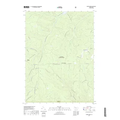
2019 Map of Cherry Grove
USGS Topo · Published 2019About this map
Allegheny National Forest dominates this landscape, showing a modern recreational and conservation network within the plateau of northwestern Pennsylvania. The small settlement of Cherry Grove sits at the intersection of Cherry Grove Rd and Farnsworth Rd, where the Cherry Grove Cem serves as a point of interest for genealogists. The map details an extensive system of wilderness corridors, including the N Country National Scenic Trail and the Tanbark Hiking path. Waterways like West Branch Tionesta Creek and Fools Cr carve through the wooded terrain, supplemented by remote water sources such as Hermit Spring and Rams Horn Spring. The presence of several snowmobile loops and the Minister Creek Hiking trails reflects the area's transition into a destination for outdoor enthusiasts while maintaining its legacy as a timber and resource region.
Find a feature on this map
40 named features on this map. Tap any name to fly to it.
Don’t see what you’re looking for? This feature index may not catch every label — zoom into the map to look around manually.
Map Details
Editions of this 2019 Cherry Grove Map
This is the sole edition of this map. No revisions or reprints were ever made.
Other maps of this area

1906 · Warren
USGS Topo · 1:62,500

1907 · Warren
USGS Topo · 1:62,500

1908 · Warren
USGS Topo · 1:62,500

1926 · Youngsville
USGS Topo · 1:62,500

1927 · Tidioute
USGS Topo · 1:48,000

1929 · Youngsville
USGS Topo · 1:62,500

1930 · Tidioute
USGS Topo · 1:62,500

1935 · Sheffield
USGS Topo · 1:48,000

1941 · Sheffield
USGS Topo · 1:62,500

1943 · Youngsville
USGS Topo · 1:62,500
Featured Places
- Cherry Grove Township, PA
- Watson Township, PA
- Howe Township, PA
- Kingsley Township, PA
- Hickory Township, PA