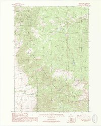
1988 Map of Cherry Lake
USGS Topo · Published 1989About this map
Lee Metcalf Wilderness lands dominate this high-elevation terrain, where the boundaries of the Beaverhead National Forest and Gallatin National Forest meet. The landscape is defined by its drainage systems, most notably Cherry Creek and its tributary, South Fork Cherry Creek, which carve through the peaks near Red Knob. At the heart of the area sits Cherry Lake, a focal point for the primitive Pack Trail network that serves as the primary means of traversal through the wilderness.
Find a feature on this map
23 named features on this map. Tap any name to fly to it.
Don’t see what you’re looking for? This feature index may not catch every label — zoom into the map to look around manually.
Map Details
Editions of this 1988 Cherry Lake Map
This is the sole edition of this map. No revisions or reprints were ever made.
Other maps of this area

1888 · Three Forks
USGS Topo · 1:250,000

1894 · Three Forks
USGS Topo · 1:250,000

1895 · Three Forks
USGS Topo · 1:250,000

1947 · Bozeman
USGS Topo · 1:250,000

1948 · Bozeman
USGS Topo · 1:250,000

1949 · Anceney
USGS Topo · 1:62,500

1949 · Ennis
USGS Topo · 1:62,500

1949 · Norris
USGS Topo · 1:62,500

1950 · Spanish Peaks
USGS Topo · 1:62,500

1951 · Norris
USGS Topo · 1:62,500