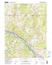
1998 Map of Cherry Run
USGS Topo · Published 2002About this map
The Potomac River forms a wide, winding bend at the intersection of West Virginia, Maryland, and Pennsylvania, creating a landscape defined by sharp mountain ridges and historic transportation corridors. The Mason and Dixon Line strikes through the northern portion of the map, separating the townships of Thompson and Warren from the southern settlements. Along the river's northern bank, the Chesapeake and Ohio Canal (Abandoned) runs parallel to the waterway, passing through the Chesapeake and Ohio Canal National Historic Park.
Find a feature on this map
52 named features on this map. Tap any name to fly to it.
Don’t see what you’re looking for? This feature index may not catch every label — zoom into the map to look around manually.
Map Details
Editions of this 1998 Cherry Run Map
This is the sole edition of this map. No revisions or reprints were ever made.
Other maps of this area

1899 · Hancock
USGS Topo · 1:62,500

1900 · Mercersburg
USGS Topo · 1:62,500

1901 · Hancock
USGS Topo · 1:62,500

1902 · Mercersburg
USGS Topo · 1:62,500

1912 · Williamsport
USGS Topo · 1:62,500

1925 · Needmore
USGS Topo · 1:48,000

1935 · Needmore
USGS Topo · 1:62,500

1939 · Needmore
USGS Topo · 1:62,500

1942 · Hagerstown
USGS Topo · 1:125,000

1943 · Hagerstown
USGS Topo · 1:125,000