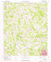
1973 Map of Cherryville
USGS Topo · Published 1976About this map
Cherryville anchors the southeastern corner of this Piedmont landscape as it appeared in the early 1970s, serving as a hub for the Seaboard Coast Line railroad. The surrounding countryside at the intersection of Gaston, Lincoln, and Cleveland counties is densely populated with small rural communities and local landmarks. To the northwest, settlements like Dora, Flay, and Fallston are linked by a network of winding roads, many of which are punctuated by historic congregational centers such as Bethlehem Ch, Davids Chapel, and Bess Chapel. The terrain is defined by the branching waterways of Buffalo Creek and the Muddy Fork, where local industry is noted by the presence of Beam Mill. This map captures a traditional North Carolina agricultural and textile region in a period of steady development, evidenced by the clustered residential growth around Cherryville and its associated Athletic Field and City Hall.
Find a feature on this map
49 named features on this map. Tap any name to fly to it.
Don’t see what you’re looking for? This feature index may not catch every label — zoom into the map to look around manually.
Map Details
Editions of this 1973 Cherryville Map
This is the sole edition of this map. No revisions or reprints were ever made.
Other maps of this area

1895 · Hickory
USGS Topo · 1:125,000

1905 · Morganton
USGS Topo · 1:125,000

1909 · Lincolnton
USGS Topo · 1:62,500

1911 · Lincolnton
USGS Topo · 1:62,500

1950 · Shelby
USGS Topo · 1:62,500

1953 · Charlotte
USGS Topo · 1:250,000

1954 · Charlotte
USGS Topo · 1:250,000

1956 · Casar
USGS Topo · 1:24,000

1960 · Charlotte
USGS Topo · 1:250,000

1962 · Charlotte
USGS Topo · 1:250,000