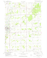
1975 Map of Chesaning East
USGS Topo · Published 1978About this map
The Shiawassee River winds through the western portion of this mid-1970s survey, providing the geographic anchor for the village of Chesaning. This settlement is marked by its grid of streets and key community landmarks like Showboat Park and several local burial grounds, including Mt Calvary Cem and Wildwood Cem. The surrounding townships of Albee and Maple Grove are defined by a meticulous network of section-line roads such as Volkmer Road and Ferden Road, which reflect the area's agricultural organization.
Find a feature on this map
54 named features on this map. Tap any name to fly to it.
Don’t see what you’re looking for? This feature index may not catch every label — zoom into the map to look around manually.
Map Details
Editions of this 1975 Chesaning East Map
This is the sole edition of this map. No revisions or reprints were ever made.
Other maps of this area

1917 · Chesaning
USGS Topo · 1:62,500

1917 · St. Charles
USGS Topo · 1:62,500

1919 · Saginaw
USGS Topo · 1:62,500

1919 · Burt
USGS Topo · 1:62,500

1921 · Burt
USGS Topo · 1:62,500

1941 · Saginaw
USGS Topo · 1:62,500

1943 · Burt
USGS Topo · 1:62,500

1943 · Chesaning
USGS Topo · 1:62,500

1943 · Saginaw
USGS Topo · 1:62,500

1943 · St. Charles
USGS Topo · 1:62,500