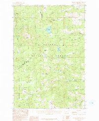
1985 Map of Chessman Reservoir
USGS Topo · Published 1986About this map
Rimini and the surrounding high country of the Northern Rockies are documented here during the mid-1980s, revealing a landscape defined by its mining heritage and public land boundaries. The map illustrates the convergence of the Helena National Forest and Deerlodge National Forest, with numerous labels for Prospect and Mine Shaft locations indicating decades of extraction across the Frohner Basin and Catarat Basin. Water management for the region is anchored by the Chessman Reservoir, while the presence of the Buffalo Trail and the remote settlement of Nellie Grant highlight the historical transit routes and small outposts that once supported the local mining economy. The terrain varies from the high Occidental Plateau to deeply carved drainages like Lump Gulch and Tenmile Creek.
Find a feature on this map
42 named features on this map. Tap any name to fly to it.
Don’t see what you’re looking for? This feature index may not catch every label — zoom into the map to look around manually.
Map Details
Editions of this 1985 Chessman Reservoir Map
This is the sole edition of this map. No revisions or reprints were ever made.
Other maps of this area

1889 · Helena
USGS Topo · 1:250,000

1893 · Helena
USGS Topo · 1:250,000

1899 · Boulder
USGS Topo · 1:125,000

1899 · Helena
USGS Topo · 1:62,500

1899 · Helena
USGS Topo · 1:250,000

1903 · Helena
USGS Topo · 1:250,000

1947 · Butte
USGS Topo · 1:250,000

1950 · Jefferson City
USGS Topo · 1:62,500

1950 · Helena
USGS Topo · 1:62,500

1954 · Basin
USGS Topo · 1:62,500