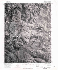
1972 Map of Chester Gap
USGS Topo · Published 1977About this map
Browntown and Chester Gap anchor this 1970s orthophotoquad, which provides a detailed aerial perspective of the northern Blue Ridge foothills in Virginia. Unlike a traditional topographic map, this survey uses transformed aerial photography to reveal the exact footprint of forest cover, agricultural clearings, and mountain roads as they existed in the spring of 1972. The concentrated settlement at Chester Gap sits at a critical high point in the terrain, while the scattered clearings near Browntown illustrate the region's rural land use before modern development. This photographic record allows for the precise study of woodlots and farm boundaries that stylized maps often simplify, making it a valuable resource for tracing changes in the Rappahannock County landscape.
Find a feature on this map
2 named features on this map. Tap any name to fly to it.
Don’t see what you’re looking for? This feature index may not catch every label — zoom into the map to look around manually.
Map Details
Editions of this 1972 Chester Gap Map
This is the sole edition of this map. No revisions or reprints were ever made.
Other maps of this area

1893 · Luray
USGS Topo · 1:125,000

1905 · Luray
USGS Topo · 1:125,000

1929 · Stony Man
USGS Topo · 1:48,000

1933 · Stony Man
USGS Topo · 1:62,500

1939 · Front Royal
USGS Topo · 1:48,000

1944 · Front Royal
USGS Topo · 1:62,500

1947 · Strasburg
USGS Topo · 1:62,500

1949 · Charlottesville
USGS Topo · 1:250,000

1950 · Strasburg
USGS Topo · 1:62,500

1956 · Charlottesville
USGS Topo · 1:250,000
Featured Places
- Chester Gap, VA
- Shenandoah Homesteads Project, VA
- Glen Echo, VA
- Browntown, VA
- Skyline View Mobile Home Park, VA