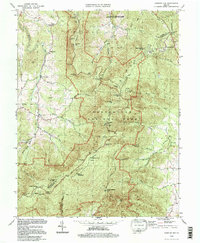
1994 Map of Chester Gap
USGS Topo · Published 1997About this map
Skyline Drive and the Appalachian Trail wind along the spine of the Blue Ridge in this mid-1990s depiction of the Virginia highlands. The map captures the interface between the protected wilderness of Shenandoah National Park and the small agricultural and residential enclaves that border it. To the east, the National Zoological Park Conservation & Research Center occupies a significant portion of the landscape near Arco. Historically significant pathways are highlighted by numerous gaps in the ridgeline, including Lands Run Gap and Chester Gap. The terrain is marked by family legacies and early settlement markers such as Williams Cem and old milling sites like Boyds Mill. Water systems like Gooney Run and the headwaters of the Jordan River define the local drainage patterns, flowing away from the high peaks of Mount Marshall and Compton Peak.
Find a feature on this map
66 named features on this map. Tap any name to fly to it.
Don’t see what you’re looking for? This feature index may not catch every label — zoom into the map to look around manually.
Map Details
Editions of this 1994 Chester Gap Map
This is the sole edition of this map. No revisions or reprints were ever made.
Other maps of this area

1893 · Luray
USGS Topo · 1:125,000

1905 · Luray
USGS Topo · 1:125,000

1929 · Stony Man
USGS Topo · 1:48,000

1933 · Stony Man
USGS Topo · 1:62,500

1939 · Front Royal
USGS Topo · 1:48,000

1944 · Front Royal
USGS Topo · 1:62,500

1947 · Strasburg
USGS Topo · 1:62,500

1949 · Charlottesville
USGS Topo · 1:250,000

1950 · Strasburg
USGS Topo · 1:62,500

1956 · Charlottesville
USGS Topo · 1:250,000
Featured Places
- Chester Gap, VA
- Shenandoah Homesteads Project, VA
- Glen Echo, VA
- Browntown, VA
- Skyline View Mobile Home Park, VA