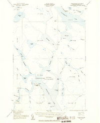
1954 Map of Chesuncook
USGS Topo · Published 1956About this map
Chesuncook Village sits at the northern reaches of the Chesuncook Lake reservoir, serving as a rare point of settlement in this Maine North Woods wilderness. The 1954 landscape is defined by its extensive logging history and water management, visible through the complex network of Carry trails and Abandoned routes that once supported the timber industry. A massive State Game Refuge encompasses Gero Island, preserving a significant portion of the lake’s interior. To the north, Chamberlain Farm stands as a lonely outpost on the shores of Chamberlain Lake, while the Penobscot River West Branch flows past Rocky Rips and Fox Hole Rips. Geologists and historians can trace the transition from river-driven logging to a more regulated lake system through features like Graveyard Pt and various spillways maintained by the Army Corps of Engineers and the Geological Survey.
Find a feature on this map
67 named features on this map. Tap any name to fly to it.
Don’t see what you’re looking for? This feature index may not catch every label — zoom into the map to look around manually.
Map Details
Editions of this 1954 Chesuncook Map
2 editions found
Other maps of this area

1953 · Telos Lake
USGS Topo · 1:62,500

1954 · Chesuncook
USGS Topo · 1:62,500

1954 · North East Carry
USGS Topo · 1:62,500

1954 · Spider Lake
USGS Topo · 1:62,500

1954 · Caucomgomoc Lake
USGS Topo · 1:62,500

1954 · Churchill Lake
USGS Topo · 1:62,500

1954 · Allagash Lake
USGS Topo · 1:62,500

1954 · Grant Farm
USGS Topo · 1:62,500

1954 · Harrington Lake
USGS Topo · 1:62,500

1954 · Presque Isle
USGS Topo · 1:250,000