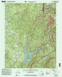
2000 Map of Chicago Park
USGS Topo · Published 2003About this map
Chicago Park serves as a central hub in this landscape where the legacies of the Gold Rush intersect with modern water management and agriculture. The terrain is deeply marked by historic mining operations, notably at Red Dog and You Bet, where extensive Placer Diggings and the Chalk Bluff formation reveal the scale of hydraulic activity. The northern section is dominated by Banner Mountain and industrial sites like the Banner Mine (Inactive) and Lava Cap Mine. The Bear River is a primary geographic feature, flowing into the expansive Rollins Reservoir which defines the southern portion of the quadrangle. Smaller settlements such as Peardale, Wolf, and Sunshine Valley are connected by a network of historic routes, including segments of the Donner Trail and the Idaho Maryland Road, illustrating the evolution of transport from pioneer trails to rural roads.
Find a feature on this map
50 named features on this map. Tap any name to fly to it.
Don’t see what you’re looking for? This feature index may not catch every label — zoom into the map to look around manually.
Map Details
Editions of this 2000 Chicago Park Map
This is the sole edition of this map. No revisions or reprints were ever made.
Other maps of this area

1888 · Smartsville
USGS Topo · 1:125,000

1891 · Colfax
USGS Topo · 1:125,000

1891 · Smartsville
USGS Topo · 1:125,000

1892 · Smartsville
USGS Topo · 1:125,000

1892 · Colfax
USGS Topo · 1:125,000

1894 · Colfax
USGS Topo · 1:125,000

1894 · Smartsville
USGS Topo · 1:125,000

1895 · Smartsville
USGS Topo · 1:125,000

1898 · Colfax
USGS Topo · 1:125,000

1900 · Colfax
USGS Topo · 1:125,000