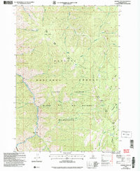
2004 Map of Chicken Peak
USGS Topo · Published 2007About this map
The Salmon River South Fork carves through the heart of this landscape, serving as a primary drainage for a network of creeks including Mackay Creek, Porphyry Creek, and Box Creek. This remote Idaho territory is defined by its inclusion within the Frank Church River of No Return Wilderness and the Payette National Forest. Notable landmarks such as Chicken Peak and Sheepeater Ridge highlight the dramatic elevation changes that characterize the region. The map documents administrative boundaries like the McCall Krassel Ranger District and specific points of interest for backcountry navigation, including Porphyry Bridge and the evocatively named Horse Heaven. These labels suggest a history of seasonal grazing and forest management in a region where water sources like Mosquito Springs and Quartz Spring were vital for both wildlife and travelers.
Find a feature on this map
32 named features on this map. Tap any name to fly to it.
Don’t see what you’re looking for? This feature index may not catch every label — zoom into the map to look around manually.
Map Details
Editions of this 2004 Chicken Peak Map
This is the sole edition of this map. No revisions or reprints were ever made.
Other maps of this area

1937 · Big Creek
USGS Topo · 1:48,000

1942 · Big Creek
USGS Topo · 1:62,500

1956 · Warren
USGS Topo · 1:62,500

1956 · Elk City
USGS Topo · 1:250,000

1960 · Elk City
USGS Topo · 1:250,000

1969 · Wolf Fang Peak
USGS Topo · 1:24,000

1969 · Big Creek
USGS Topo · 1:24,000

1969 · Pilot Peak
USGS Topo · 1:24,000

1978 · Mosquito Peak
USGS Topo · 1:24,000

1978 · Chicken Peak
USGS Topo · 1:24,000