
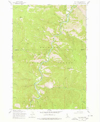
1969 Map of Pilot Peak
USGS Topo · Published 1971About this map
The South Fork Salmon River carves a deep path through the Payette National Forest in this 1969 U.S. Forest Service study of the Idaho backcountry. This region is characterized by steep elevation shifts, rising from the riverbed to prominent heights at China Mountain and Pilot Peak. The landscape is a network of drainage systems including Mayflower Creek, Big Flat Creek, and Elk Creek, which define the local topography.
Find a feature on this map
39 named features on this map. Tap any name to fly to it.
Don’t see what you’re looking for? This feature index may not catch every label — zoom into the map to look around manually.
Map Details
Editions of this 1969 Pilot Peak Map
2 editions found
Other maps of this area

1937 · Big Creek
USGS Topo · 1:48,000

1942 · Big Creek
USGS Topo · 1:62,500

1956 · Warren
USGS Topo · 1:62,500

1956 · Elk City
USGS Topo · 1:250,000

1960 · Elk City
USGS Topo · 1:250,000

1969 · Profile Gap
USGS Topo · 1:24,000

1969 · Pony Meadows
USGS Topo · 1:24,000

1969 · Parks Peak
USGS Topo · 1:24,000

1969 · Wolf Fang Peak
USGS Topo · 1:24,000

1969 · Williams Peak
USGS Topo · 1:24,000