
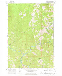
1969 Map of Williams Peak
USGS Topo · Published 1971About this map
The Salmon River and Secesh River converge in this remote section of the Payette National Forest, carving through a landscape defined by dramatic elevation changes. Small, isolated outposts such as Browns Camp and Zena appear near the western edge of the survey, reflecting the limited but persistent human footprint in these mountain reaches. A single Tramway and scattered Prospect markings indicate early mining interest, particularly near the South East Fork.
Find a feature on this map
47 named features on this map. Tap any name to fly to it.
Don’t see what you’re looking for? This feature index may not catch every label — zoom into the map to look around manually.
Map Details
Editions of this 1969 Williams Peak Map
2 editions found
Other maps of this area

1956 · Elk City
USGS Topo · 1:250,000

1957 · Challis
USGS Topo · 1:250,000

1960 · Elk City
USGS Topo · 1:250,000

1960 · Challis
USGS Topo · 1:250,000

1963 · Challis
USGS Topo · 1:250,000

1969 · Loon Lake
USGS Topo · 1:24,000

1969 · Pony Meadows
USGS Topo · 1:24,000

1969 · Enos Lake
USGS Topo · 1:24,000

1969 · Parks Peak
USGS Topo · 1:24,000

1969 · Pilot Peak
USGS Topo · 1:24,000