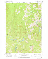
1969 Map of Williams Peak
USGS Topo · Published 1978About this map
The South Fork Salmon River and its major tributaries, the Secesh River and the East Fork South Fork Salmon River, dominate this mountainous region of the Payette National Forest. This remote landscape in Valley County is characterized by high-elevation landmarks such as Williams Peak and Rainbow Ridge, connected primarily by an intricate network of pack trails and jeep trails. One such path leads to Browns Camp, a named settlement area nestled near the confluence of Zena Creek and the Secesh.
Find a feature on this map
48 named features on this map. Tap any name to fly to it.
Don’t see what you’re looking for? This feature index may not catch every label — zoom into the map to look around manually.
Map Details
Editions of this 1969 Williams Peak Map
2 editions found
Other maps of this area

1956 · Elk City
USGS Topo · 1:250,000

1957 · Challis
USGS Topo · 1:250,000

1960 · Elk City
USGS Topo · 1:250,000

1960 · Challis
USGS Topo · 1:250,000

1963 · Challis
USGS Topo · 1:250,000

1969 · Loon Lake
USGS Topo · 1:24,000

1969 · Pony Meadows
USGS Topo · 1:24,000

1969 · Enos Lake
USGS Topo · 1:24,000

1969 · Parks Peak
USGS Topo · 1:24,000

1969 · Williams Peak
USGS Topo · 1:24,000