
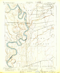
1912 Map of Chico Landing
USGS Topo · Published 1912About this map
The Sacramento River carves a serpentine path through this Northern California landscape, defining the border between Glenn and Butte counties. The river's intricate hydrology is fully visible through numerous bypasses and side channels like Kusal Slough, Perch Slough, and the dramatic loop at Lincoln Bend. This 1912 survey captures the transition from old river-based commerce to the rising rail economy, centered around the settlement of Chico Landing where the Northern Electric RR crosses the water. To the east, the vast tracts of Rancho Farwell and Llano Seco indicate the enduring influence of early land grants on the region's agricultural layout. Local life is anchored by a network of rural schoolhouses, including Bidwell School and Parrott School, serving the families settled along the fertile reaches of Little Chico Creek and Sandy Gulch Creek.
Find a feature on this map
32 named features on this map. Tap any name to fly to it.
Don’t see what you’re looking for? This feature index may not catch every label — zoom into the map to look around manually.
Map Details
Editions of this 1912 Chico Landing Map
2 editions found
Other maps of this area

1891 · Chico
USGS Topo · 1:125,000

1893 · Chico
USGS Topo · 1:125,000

1895 · Chico
USGS Topo · 1:125,000

1904 · Vina
USGS Topo · 1:62,500

1906 · Willows
USGS Topo · 1:62,500

1912 · Durham
USGS Topo · 1:31,680

1912 · Nord
USGS Topo · 1:31,680

1912 · Nelson
USGS Topo · 1:31,680

1912 · Keefers
USGS Topo · 1:31,680
1912 · Newhard
USGS Topo · 1:31,680