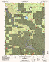
1995 Map of Childs Meadows
USGS Topo · Published 1997About this map
Childs Meadows and the high volcanic terrain of the Lassen National Forest define this 1995 survey, which details a landscape marked by ancient lava flows and vital water sources. The map records several localized landmarks such as Stump Ranch and Smith Cabin, alongside industrial remnants like a Cinder Pit and a Gravel Pit. Significant geological features include Ice Cave Mountain and Fire Mountain, while the hydrology of the region is traced through the headwaters of the South Fork Feather River and the meandering Lost Creek. Transportation and communication infrastructure are represented by the Spencer Trail and a designated Telephone Cable corridor. This era of forest management is further evidenced by a marked Helispot and several corrals, reflecting the area's continued use for grazing and fire suppression near the Tehama and Plumas county line.
Find a feature on this map
45 named features on this map. Tap any name to fly to it.
Don’t see what you’re looking for? This feature index may not catch every label — zoom into the map to look around manually.
Map Details
Editions of this 1995 Childs Meadows Map
This is the sole edition of this map. No revisions or reprints were ever made.
Other maps of this area

1886 · Lassen Peak
USGS Topo · 1:250,000

1892 · Lassen Peak
USGS Topo · 1:250,000

1894 · Lassen Peak
USGS Topo · 1:250,000

1935 · Paynes Creek
USGS Topo · 1:96,000

1941 · Mineral
USGS Topo · 1:125,000

1955 · Westwood
USGS Topo · 1:250,000

1956 · Lassen Peak
USGS Topo · 1:62,500

1956 · Mt. Harkness
USGS Topo · 1:62,500

1958 · Westwood
USGS Topo · 1:250,000

1958 · Jonesville
USGS Topo · 1:62,500