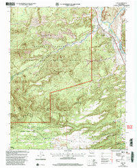
2002 Map of Chili
USGS Topo · Published 2003About this map
Rio Chama flows through a landscape defined by traditional land grants and Indigenous territory in this northern New Mexico quadrangle. The settlement of Chili is the primary hub along the river, accompanied by the nearby Immaculate Conception Ch and the neighboring community of La Cuchilla. The map reveals a complex intersection of historic boundaries, including the Juan Jose Lobato Grant, Bartolome Sanchez Grant, and the Santa Clara Indian Reservation.
Find a feature on this map
31 named features on this map. Tap any name to fly to it.
Don’t see what you’re looking for? This feature index may not catch every label — zoom into the map to look around manually.
Map Details
Editions of this 2002 Chili Map
This is the sole edition of this map. No revisions or reprints were ever made.
Other maps of this area

1892 · Santa Clara
USGS Topo · 1:125,000

1918 · Abiquiu
USGS Topo · 1:125,000

1952 · Puye
USGS Topo · 1:24,000

1952 · Guaje Mountain
USGS Topo · 1:24,000

1953 · Espanola
USGS Topo · 1:24,000

1953 · Chili
USGS Topo · 1:24,000

1953 · Abiquiu
USGS Topo · 1:24,000

1953 · Medanales
USGS Topo · 1:24,000

1953 · Vallecitos
USGS Topo · 1:24,000

1953 · San Juan Pueblo
USGS Topo · 1:24,000