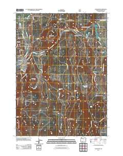
2011 Map of Chiloquin
USGS Topo · Published 2011About this map
The confluence of the Sprague River and the Williamson River anchors this 2011 survey of the Chiloquin area, showing the community just east of Upper Klamath Lake. The town of Chiloquin is detailed alongside its neighbor Pine Ridge, which sits near the northern river fork. The map reflects a landscape defined by both tribal land management, seen in the Special Trust Land, and local industrial history, with the Braymill settlement and its nearby Braymill Cinder Pit to the northeast. High points like Cave Mountain and the Canby Mountains rise above the river valleys, while local landmarks such as Friendship Cemetery and the Chiloquin Post Office provide essential reference points for genealogists. Water sources are frequent across the terrain, from the Crystal Castle Spring to the Rocky Hole Reservoir and Grouse Spring, illustrating the hydrologic network essential to this part of Klamath County.
Find a feature on this map
45 named features on this map. Tap any name to fly to it.
Don’t see what you’re looking for? This feature index may not catch every label — zoom into the map to look around manually.
Map Details
Editions of this 2011 Chiloquin Map
This is the sole edition of this map. No revisions or reprints were ever made.
Other maps of this area

1889 · Klamath
USGS Topo · 1:250,000

1894 · Klamath
USGS Topo · 1:250,000

1955 · Klamath Falls
USGS Topo · 1:250,000

1956 · Calimus Butte
USGS Topo · 1:62,500

1957 · Chiloquin
USGS Topo · 1:62,500

1957 · Swan Lake
USGS Topo · 1:62,500

1957 · Modoc Point
USGS Topo · 1:62,500

1958 · Klamath Falls
USGS Topo · 1:250,000

1980 · Williamson River
USGS Topo · 1:100,000
1985 · Shoalwater Bay
USGS Topo · 1:24,000