
1957 Map of Chiloquin
USGS Topo · Published 1959About this map
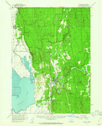
Klamath Indian Reservation lands dominate this mid-century landscape, centered on the confluence of the Sprague River and the Williamson River. The settlement of Chiloquin serves as a local hub, featuring a High School and proximity to the Southern Pacific rail line. To the northwest, the historic Fort Klamath area is mapped alongside the Jackson F Kimball State Park, while the Klamath Agency and Williamson River Mission reflect the administrative and social history of the region. The map captures a complex water system including the Sevenmile Canal and Agency Lake, supporting local infrastructure like the Williamson River Pumping Plant and the State Fish Hatchery. Significant volcanic features such as Solomon Butte and Cave Mountain rise above the river valleys, marking the transition from the marshy lowlands to the higher timbered draws like Copperfield Draw.
Find a feature on this map
50 named features on this map. Tap any name to fly to it.
Don’t see what you’re looking for? This feature index may not catch every label — zoom into the map to look around manually.
Map Details
Editions of this 1957 Chiloquin Map
3 editions found

Other maps of this area

1889 · Klamath
USGS Topo · 1:250,000

1891 · Ashland
USGS Topo · 1:250,000

1893 · Ashland
USGS Topo · 1:250,000

1894 · Klamath
USGS Topo · 1:250,000

1897 · Ashland
USGS Topo · 1:250,000

1955 · Lake O' Woods
USGS Topo · 1:62,500

1955 · Pelican Butte
USGS Topo · 1:62,500

1955 · Klamath Falls
USGS Topo · 1:250,000

1955 · Medford
USGS Topo · 1:250,000

1956 · Calimus Butte
USGS Topo · 1:62,500