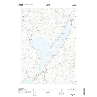
2021 Map of China Lake
USGS Topo · Published 2021About this map
China Lake dominates this central Maine landscape, serving as a focal point for the surrounding communities of North Vassalboro, East Vassalboro, China, and South China. The map reveals a dense distribution of family and community burial grounds, such as Hodges Cem, Jones Cem, and the Friends Churchyard Cem, which indicate long-standing patterns of rural settlement and local genealogy. To the west, the Outlet Stream flows through North Vassalboro, while the south reveals the headwaters of the W Br Sheepscot River near Threemile Pond. The land is characterized by distinctive points along the water like Killdeer Point and Wentworth Point, alongside prominent elevations such as Priest Hill. This 2021 USGS study provides a clear view of the modern road network, including the many "Fire Roads" that provide access to the lake's indented shoreline and islands like Indian Island.
Find a feature on this map
102 named features on this map. Tap any name to fly to it.
Don’t see what you’re looking for? This feature index may not catch every label — zoom into the map to look around manually.
Map Details
Editions of this 2021 China Lake Map
This is the sole edition of this map. No revisions or reprints were ever made.
Other maps of this area

1892 · Waterville
USGS Topo · 1:62,500

1893 · Vassalboro
USGS Topo · 1:62,500

1898 · Vassalboro
USGS Topo · 1:62,500

1916 · Liberty
USGS Topo · 1:62,500

1926 · Burnham
USGS Topo · 1:62,500

1941 · Vassalboro
USGS Topo · 1:62,500

1942 · Liberty
USGS Topo · 1:62,500

1943 · Vassalboro
USGS Topo · 1:62,500

1943 · Waterville
USGS Topo · 1:62,500

1948 · Bangor
USGS Topo · 1:250,000