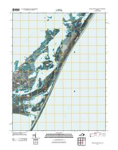
2011 Map of Chincoteague East
USGS Topo · Published 2011About this map
Chincoteague and the surrounding barrier island landscape are detailed in this coastal survey, showing the intricate network of marshes, guts, and bays that define the Eastern Shore. The settlement of Birch Town and the town of Chincoteague occupy the island's interior, supported by infrastructure like the Chincoteague Post Office. Local family and community history is preserved in the locations of Redman Cemetery, Ridge Cemetery, and Mechanics Cemetery, which sit near the residential grid. Across the Assateague Channel, the iconic Assateague Lighthouse stands as a landmark on the southern reach of Assateague Island. The map illustrates the dynamic geography of the Atlantic coast, from the wide expanse of Toms Cove to the smaller, curiously named Hairy Head Pond and Deep Hole. These wetlands, including Oyster Bay and Booths Bay, reflect the region's long-standing connection to the maritime environment and the tidal changes of the Atlantic Ocean.
Find a feature on this map
40 named features on this map. Tap any name to fly to it.
Don’t see what you’re looking for? This feature index may not catch every label — zoom into the map to look around manually.
Map Details
Editions of this 2011 Chincoteague East Map
This is the sole edition of this map. No revisions or reprints were ever made.
Other maps of this area

1901 · Snow Hill
USGS Topo · 1:62,500

1901 · Green Run
USGS Topo · 1:62,500

1938 · Green Run
USGS Topo · 1:62,500

1942 · Chincoteague East
USGS Topo · 1:24,000

1942 · Wallops Island
USGS Topo · 1:24,000

1943 · Boxiron
USGS Topo · 1:31,680

1943 · Whittington Point
USGS Topo · 1:31,680

1943 · Chincoteague West
USGS Topo · 1:31,680
1943 · Girdletree
USGS Topo · 1:31,680

1943 · Wallops Island
USGS Topo · 1:31,680