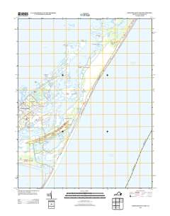
2013 Map of Chincoteague East
USGS Topo · Published 2013About this map
Chincoteague Island and its eastern neighbor, Assateague Island, dominate this coastal survey of the Virginia shoreline. The settlement of Chincoteague is densely mapped along the western shore, with the smaller community of Birch Town located further south near Eel Creek. This era of the Eastern Shore landscape is defined by the complex network of tidal guts and coves, including Wildcat Gut and East Gut, which separate the mainland from the barrier beaches. The Assateague Lighthouse stands as a prominent landmark on the southern portion of the island, overlooking the approach to Toms Cove. On the barrier side, Bow Beach stretches along the Atlantic Ocean, while interior features like Silver Lake and Sawmill Pond suggest the unique hydrology of these narrow landmasses. The map records a modern road network, including Maddox Blvd and Main St, facilitating access between the residential areas and the surrounding wildlife habitat.
Find a feature on this map
63 named features on this map. Tap any name to fly to it.
Don’t see what you’re looking for? This feature index may not catch every label — zoom into the map to look around manually.
Map Details
Editions of this 2013 Chincoteague East Map
This is the sole edition of this map. No revisions or reprints were ever made.
Other maps of this area

1901 · Snow Hill
USGS Topo · 1:62,500

1901 · Green Run
USGS Topo · 1:62,500

1938 · Green Run
USGS Topo · 1:62,500

1942 · Chincoteague East
USGS Topo · 1:24,000

1942 · Wallops Island
USGS Topo · 1:24,000

1943 · Boxiron
USGS Topo · 1:31,680

1943 · Whittington Point
USGS Topo · 1:31,680

1943 · Chincoteague West
USGS Topo · 1:31,680
1943 · Girdletree
USGS Topo · 1:31,680

1943 · Wallops Island
USGS Topo · 1:31,680