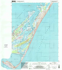
1999 Map of Chincoteague East
USGS Topo · Published 2000About this map
Chincoteague island life is documented here at the close of the century, showing the dense residential and maritime development of the town contrasted with the protected marshlands to the east. The map captures local community landmarks including the Chincoteague High Sch, Christ Sanctified Holy Ch, and several family burial grounds such as Mechanics Cem and Redman Cem. The southern end of the island transitions from the Trailer Park and Birch Town into the complex waterways of Toms Cove and Chincoteague Inlet.
Find a feature on this map
62 named features on this map. Tap any name to fly to it.
Don’t see what you’re looking for? This feature index may not catch every label — zoom into the map to look around manually.
Map Details
Editions of this 1999 Chincoteague East Map
This is the sole edition of this map. No revisions or reprints were ever made.
Other maps of this area

1901 · Snow Hill
USGS Topo · 1:62,500

1901 · Green Run
USGS Topo · 1:62,500

1938 · Green Run
USGS Topo · 1:62,500

1942 · Chincoteague East
USGS Topo · 1:24,000

1942 · Wallops Island
USGS Topo · 1:24,000

1943 · Boxiron
USGS Topo · 1:31,680

1943 · Whittington Point
USGS Topo · 1:31,680

1943 · Chincoteague West
USGS Topo · 1:31,680
1943 · Girdletree
USGS Topo · 1:31,680

1943 · Wallops Island
USGS Topo · 1:31,680