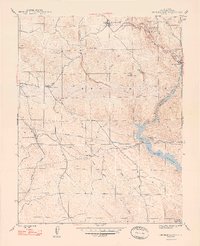
1948 Map of Chinese Camp
USGS Topo · Published 1948About this map
Chinese Camp serves as a northern anchor for this 1940s landscape, which is heavily shaped by the industrial remnants of the Mother Lode gold region. The map captures an era when mining infrastructure still dominated the local topography, featuring concentrated activity along Woods Creek such as the Eagle-Shawmut Mine, its associated Eagle-Shawmut Mill, and the Mammoth Mine. The southern portion of the quadrangle is defined by the Tuolumne River and the expanding waters of the Don Pedro Reservoir.
Find a feature on this map
29 named features on this map. Tap any name to fly to it.
Don’t see what you’re looking for? This feature index may not catch every label — zoom into the map to look around manually.
Map Details
Editions of this 1948 Chinese Camp Map
2 editions found
Other maps of this area

1893 · Sonora
USGS Topo · 1:125,000

1896 · Sonora
USGS Topo · 1:125,000

1897 · Sonora
USGS Topo · 1:125,000

1898 · Sonora
USGS Topo · 1:125,000

1915 · La Grange
USGS Topo · 1:24,000

1916 · Cooperstown
USGS Topo · 1:31,680

1916 · Copperopolis
USGS Topo · 1:62,500

1919 · La Grange
USGS Topo · 1:31,680

1942 · Copperopolis
USGS Topo · 1:62,500

1944 · Merced Falls
USGS Topo · 1:62,500