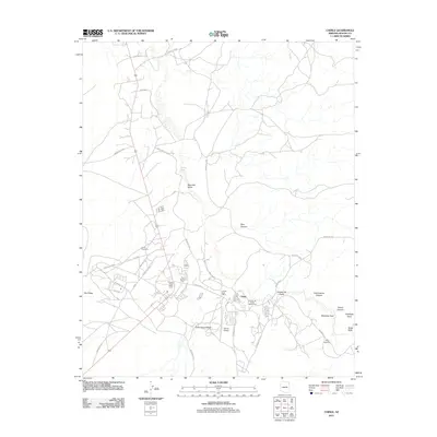
2011 Map of Chinle
USGS Topo · Published 2011About this map
Chinle serves as a vital community hub in northeastern Arizona, where the confluence of several geological and cultural landmarks occurs. The landscape is defined by the entrance to Canyon de Chelly, a region of significant tribal importance evidenced by the Navajo Tribal Utility and the Chinle Cemetery. This 2011 survey illustrates the modern layout of the settlement, documenting key infrastructure including the Chinle Post Office, the Chinle Airport, and various service points like the Tsos Trading Post. Water sources like Nazlini Wash and Cottonwood Wash cut through the terrain, which rises into prominent features such as Beautiful Valley and Red Mesa. To the east, the map captures the beginning of deep canyon systems, featuring the Tsegi Overlook and the Canyon de Chelly Trading Post.
Find a feature on this map
36 named features on this map. Tap any name to fly to it.
Don’t see what you’re looking for? This feature index may not catch every label — zoom into the map to look around manually.
Map Details
Editions of this 2011 Chinle Map
This is the sole edition of this map. No revisions or reprints were ever made.
Other maps of this area

1892 · Canyon De Chelly
USGS Topo · 1:250,000

1954 · Shiprock
USGS Topo · 1:250,000

1955 · Chinle 4 NE
USGS Topo · 1:24,000

1955 · Chinle 4 SE
USGS Topo · 1:24,000

1955 · Sonsala Butte 2 SW
USGS Topo · 1:24,000
1955 · Sonsala Butte 3 SW
USGS Topo · 1:24,000
1955 · Sonsala Butte 3 NW
USGS Topo · 1:24,000
1955 · Canyon Del Muerto
USGS Topo · 1:62,500
1955 · Yellowstone Canyon
USGS Topo · 1:62,500

1958 · Shiprock
USGS Topo · 1:250,000