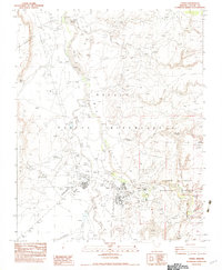
1982 Map of Chinle
USGS Topo · Published 1983About this map
Chinle serves as a vital hub within the Navajo Indian Reservation, positioned where the seasonal flow of Chinle Wash meets the dramatic gateway of the Canyon De Chelly National Monument. The settlement pattern recorded here in the late 1970s reflects a community balancing traditional land use with modern infrastructure, featuring a Rodeo Ground alongside an Extended Care Center and a 55-foot wide Dirt Airstrip.
Find a feature on this map
31 named features on this map. Tap any name to fly to it.
Don’t see what you’re looking for? This feature index may not catch every label — zoom into the map to look around manually.
Map Details
Editions of this 1982 Chinle Map
This is the sole edition of this map. No revisions or reprints were ever made.
Other maps of this area

1892 · Canyon De Chelly
USGS Topo · 1:250,000

1954 · Shiprock
USGS Topo · 1:250,000

1955 · Chinle 4 NE
USGS Topo · 1:24,000

1955 · Chinle 4 SE
USGS Topo · 1:24,000

1955 · Sonsala Butte 2 SW
USGS Topo · 1:24,000
1955 · Sonsala Butte 3 SW
USGS Topo · 1:24,000
1955 · Sonsala Butte 3 NW
USGS Topo · 1:24,000
1955 · Canyon Del Muerto
USGS Topo · 1:62,500
1955 · Yellowstone Canyon
USGS Topo · 1:62,500

1958 · Shiprock
USGS Topo · 1:250,000