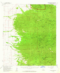
1958 Map of Chiricahua Peak
USGS Topo · Published 1962About this map
Chiricahua National Monument and the high ridges of the Chiricahua Mountains dominate this late-1950s landscape, where dense pack trails and jeep tracks intersect a terrain of remote lookouts and seasonal camps. Rising to nearly ten thousand feet at Chiricahua Peak, the area served as a critical hub for forest management and recreation, evidenced by the Turkey Cr Ranger Sta and numerous sites like Bathtub Forest Camp.
Find a feature on this map
103 named features on this map. Tap any name to fly to it.
Don’t see what you’re looking for? This feature index may not catch every label — zoom into the map to look around manually.
Map Details
Editions of this 1958 Chiricahua Peak Map
3 editions found

Other maps of this area

1916 · Pearce
USGS Topo · 1:125,000

1917 · San Simon
USGS Topo · 1:125,000

1917 · Chiricahua
USGS Topo · 1:125,000

1919 · Chiricahua
USGS Topo · 1:125,000

1922 · Willcox
USGS Topo · 1:125,000

1922 · Swisshelm
USGS Topo · 1:62,500

1926 · Light
USGS Topo · 1:62,500

1926 · Cochise Head
USGS Topo · 1:62,500

1926 · Rodeo
USGS Topo · 1:62,500

1926 · Rucker
USGS Topo · 1:62,500