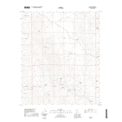
2020 Map of Chise
USGS Topo · Published 2020About this map
Chise serves as the central settlement point in this arid landscape, located along the winding path of Cuchillo Negro Creek. The terrain is defined by dramatic relief, ranging from the prominent Sierra Cuchillo and Cuchillo Mtn in the north to the distinctive Twin Peaks and Cross Mtn further south. Water management is a primary feature of the local geography, evidenced by several strategically placed reservoirs such as Margarita Tank, Victoria Tank, and Jakes Tank, alongside natural features like Warm Springs and Willow Spring. The map documents a complex system of drainage and erosion through numerous named canyons, including Old Mill Canyon, Schoolhouse Canyon, and Montoya Canyon, which intersect the high desert plateau. Transport in this part of Sierra County relies on a network of unpaved routes like Chiz RD and various county roads that navigate the difficult topography.
Find a feature on this map
40 named features on this map. Tap any name to fly to it.
Don’t see what you’re looking for? This feature index may not catch every label — zoom into the map to look around manually.
Map Details
Editions of this 2020 Chise Map
This is the sole edition of this map. No revisions or reprints were ever made.
Other maps of this area

1954 · Tularosa
USGS Topo · 1:250,000

1958 · Tularosa
USGS Topo · 1:250,000

1961 · Priest Tank
USGS Topo · 1:24,000

1961 · Williamsburg NW
USGS Topo · 1:24,000

1961 · Monticello
USGS Topo · 1:24,000

1963 · Thumb Tank Peak
USGS Topo · 1:24,000

1963 · Sugarloaf Peak
USGS Topo · 1:24,000

1965 · Winston
USGS Topo · 1:24,000

1965 · Iron Mountain
USGS Topo · 1:24,000

1965 · Jaralosa Mountain
USGS Topo · 1:24,000