
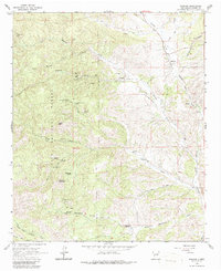
1965 Map of Winston
USGS Topo · Published 1967About this map
Winston and the nearby settlement of Chloride anchor this mid-1960s study of the Black Range foothills. The landscape is defined by its mining history, with numerous named claims such as the Wall Street Mine, U S Treasury Mine, and St Cloud Mines scattered across the high ridges and canyons. These industrial sites are linked by a network of unimproved roads and a Jeep Trail winding through the Gila National Forest. In the lower elevations, water resources are meticulously recorded, including named springs like Woodhouse Spring and Monument Spring, alongside several windmills and wells. The map captures a transition from the rugged mining operations at Gold Hill and Way-Up Mountain to the quieter civic features of the era, such as the Santo Niño Cem and the local Schoolhouse. This record is particularly valuable for genealogists and researchers tracing the 19th-century mining legacy that persisted into the mid-20th century.
Find a feature on this map
48 named features on this map. Tap any name to fly to it.
Don’t see what you’re looking for? This feature index may not catch every label — zoom into the map to look around manually.
Map Details
Editions of this 1965 Winston Map
2 editions found
Other maps of this area

1949 · Lookout Mountain
USGS Topo · 1:62,500

1954 · Tularosa
USGS Topo · 1:250,000

1958 · Tularosa
USGS Topo · 1:250,000

1963 · Thumb Tank Peak
USGS Topo · 1:24,000

1963 · Reeds Peak
USGS Topo · 1:24,000

1963 · Sugarloaf Peak
USGS Topo · 1:24,000

1965 · Iron Mountain
USGS Topo · 1:24,000

1965 · Jaralosa Mountain
USGS Topo · 1:24,000
1965 · Chise
USGS Topo · 1:24,000

1979 · Truth or Consequences
USGS Topo · 1:100,000