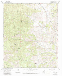
1965 Map of Winston
USGS Topo · Published 1986About this map
Winston and the nearby settlement of Chloride anchor this mid-1960s survey of Sierra County, New Mexico. The landscape is defined by its deep mining heritage, with numerous active and dormant sites dotting the terrain, including the U S Treasury Mine, Gold Hill Mine, and Wall Street Mine. These workings are concentrated along the canyon walls of Mineral Creek and Chloride Creek, reflecting a late-19th-century silver and gold rush that shaped the region's development within the eastern edge of the Gila National Forest. Evidence of local Catholic history is preserved at the Santo Niño Cem, while the remote Midnight Cabin and Stone Ranch suggest the isolation of high-altitude ranching and prospecting life. The topography is dominated by prominent heights like Hagins Peak and Way-Up Mountain, rising above a complex network of canyons and seasonal watercourses such as Cuchillo Negro Creek and Monument Creek.
Find a feature on this map
50 named features on this map. Tap any name to fly to it.
Don’t see what you’re looking for? This feature index may not catch every label — zoom into the map to look around manually.
Map Details
Editions of this 1965 Winston Map
2 editions found
Other maps of this area

1949 · Lookout Mountain
USGS Topo · 1:62,500

1954 · Tularosa
USGS Topo · 1:250,000

1958 · Tularosa
USGS Topo · 1:250,000

1963 · Thumb Tank Peak
USGS Topo · 1:24,000

1963 · Reeds Peak
USGS Topo · 1:24,000

1963 · Sugarloaf Peak
USGS Topo · 1:24,000

1965 · Winston
USGS Topo · 1:24,000

1965 · Iron Mountain
USGS Topo · 1:24,000

1965 · Jaralosa Mountain
USGS Topo · 1:24,000
1965 · Chise
USGS Topo · 1:24,000