
1965 Map of Iron Mountain
USGS Topo · Published 1967About this map
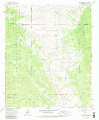
Gila National Forest encompasses the western half of this landscape, where the terrain is marked by a legacy of resource extraction and ranching. Several historic mining operations are scattered across the slopes, including the Minnehaha Mine, Republic Mine, and Blackhawk Mine further south. These sites, along with the Paymaster Mine and Invincible Mine, reflect the mid-century mineral prospecting that defined this region of New Mexico. The small settlement of Grafton is situated near Turkey Creek, while the eastern portion of the map is dominated by the high ridge of Iron Mountain and Reilly Peak. Drainage patterns are dictated by prominent watercourses such as Poverty Creek and Hipp Creek, which cut through the dry canyons. Ranching activity is evident at Sage Ranch and Moore Ranch, connected by the rugged North Pack Trail and a network of unimproved roads.
Find a feature on this map
40 named features on this map. Tap any name to fly to it.
Don’t see what you’re looking for? This feature index may not catch every label — zoom into the map to look around manually.
Map Details
Editions of this 1965 Iron Mountain Map
2 editions found
Other maps of this area

1949 · Lookout Mountain
USGS Topo · 1:62,500

1954 · Tularosa
USGS Topo · 1:250,000

1958 · Tularosa
USGS Topo · 1:250,000

1964 · Montoya Butte
USGS Topo · 1:24,000

1965 · Winston
USGS Topo · 1:24,000

1965 · Jaralosa Mountain
USGS Topo · 1:24,000
1965 · Chise
USGS Topo · 1:24,000

1965 · Wahoo Peak
USGS Topo · 1:24,000

1979 · Truth or Consequences
USGS Topo · 1:100,000

1979 · San Mateo Mountains
USGS Topo · 1:100,000