
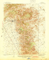
1944 Map of Chloride
USGS Topo · Published 1944About this map
Mining operations and remote desert homesteads define this 1939 survey of the Cerbat Mountains in Mohave County. The town of Chloride stands as a central hub for the surrounding industrial landscape, which includes major workings like the Tennessee Mine and the Arizona Magma Mine. The map documents a rugged economic geography where mineral extraction and ranching coexist, from the Keystone Mines near Mineral Park to family holdings like Lewis Ranch and Goose Ranch. To the south, the whimsical settlement of Santa Claus sits along the road in the Hualpai Valley, providing a distinct contrast to the heavy labor of the Stockton Mine and White Eagle Mine tucked into the canyons. Prominent summits like Cerbat Peak and Turquoise Mtn anchor the terrain, while reliable water sources like Putman Spr and Cedar Spr mark essential points in an otherwise arid expanse.
Find a feature on this map
53 named features on this map. Tap any name to fly to it.
Don’t see what you’re looking for? This feature index may not catch every label — zoom into the map to look around manually.
Map Details
Editions of this 1944 Chloride Map
2 editions found
Other maps of this area

1886 · Diamond Creek
USGS Topo · 1:250,000

1886 · Camp Mohave
USGS Topo · 1:250,000

1892 · Diamond Creek
USGS Topo · 1:250,000

1892 · Camp Mohave
USGS Topo · 1:250,000

1939 · Chloride
USGS Topo · 1:48,000

1942 · Camp Mohave
USGS Topo · 1:250,000

1947 · Kingman
USGS Topo · 1:250,000

1948 · Kingman
USGS Topo · 1:250,000

1948 · Williams
USGS Topo · 1:250,000

1954 · Kingman
USGS Topo · 1:250,000