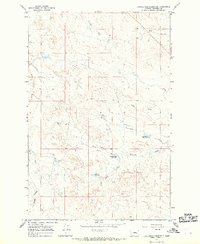
1965 Map of Christenson Reservoir
USGS Topo · Published 1969About this map
Christenson Reservoir and the surrounding drainage basins of Garfield County define this mid-century ranching landscape. The area is characterized by a complex network of seasonal watercourses and coulees, including Graveyard Creek, Myers Coulee, and Artz Coulee, which carve through the high plains. Small-scale water management is evident through scattered impoundments such as Antone Reservoir and Section Four Reservoir, which provided vital resources for livestock in this arid environment. A prominent Mesa stands as a central landmark above the West Branch Coulee, while the serpentine paths of Lone Tree Creek and Jacques Creek trace the southern reaches of the quadrangle, illustrating the natural erosion patterns and land-use requirements of Eastern Montana during the 1960s.
Find a feature on this map
12 named features on this map. Tap any name to fly to it.
Don’t see what you’re looking for? This feature index may not catch every label — zoom into the map to look around manually.
Map Details
Editions of this 1965 Christenson Reservoir Map
This is the sole edition of this map. No revisions or reprints were ever made.
Other maps of this area

1954 · Jordan
USGS Topo · 1:250,000

1954 · Forsyth
USGS Topo · 1:250,000

1956 · Jordan
USGS Topo · 1:250,000

1957 · Forsyth
USGS Topo · 1:250,000

1958 · Jordan
USGS Topo · 1:250,000

1958 · Forsyth
USGS Topo · 1:250,000

1964 · Jordan
USGS Topo · 1:250,000

1965 · Black Hills
USGS Topo · 1:24,000

1965 · Needle Butte Reservoir
USGS Topo · 1:24,000

1965 · Needle Butte
USGS Topo · 1:24,000