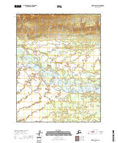
2018 Map of Christian A-6 SW
USGS Topo · Published 2018About this map
Teedriinjik River dominates this northern Alaskan landscape, carving a complex network of braids and bars through the interior wilderness. The river’s shifting channels and the surrounding wetland system suggest a highly dynamic environment where seasonal water levels dictate the shape of the land. In the northern reaches of the quadrangle, the terrain rises sharply from the river valley into a series of ridges and steep contours, while the southern half remains a broad, low-lying expanse defined by the river’s path. This 2018 survey provides a clear view of the hydrological patterns of the Yukon-Koyukuk region before more recent environmental changes further altered the basin's drainage.
Find a feature on this map
10 named features on this map. Tap any name to fly to it.
Don’t see what you’re looking for? This feature index may not catch every label — zoom into the map to look around manually.
Map Details
Editions of this 2018 Christian A-6 SW Map
This is the sole edition of this map. No revisions or reprints were ever made.
Other maps of this area

1951 · Fort Yukon
USGS Topo · 1:250,000

1951 · Chandalar
USGS Topo · 1:250,000

1951 · Christian
USGS Topo · 1:250,000

1951 · Beaver
USGS Topo · 1:250,000

1956 · Chandalar
USGS Topo · 1:250,000

1956 · Beaver
USGS Topo · 1:250,000

1956 · Christian
USGS Topo · 1:250,000

1956 · Fort Yukon
USGS Topo · 1:250,000
1956 · Fort Yukon D-6
USGS Topo · 1:63,360

1964 · Chandalar
USGS Topo · 1:250,000