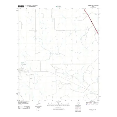
2010 Map of Christine East
USGS Topo · Published 2010About this map
Christine serves as the primary focal point in this south-central Texas landscape, situated along the western edge of a region defined by an intricate network of seasonal drainage. Water management and rural infrastructure are prominent, evidenced by McLerran Dam and McLerran Lake just north of the settlement. The area's genealogy is anchored by the Bautista Cemetery located along the stretch between La Parita Creek and Turkey Creek.
Find a feature on this map
25 named features on this map. Tap any name to fly to it.
Don’t see what you’re looking for? This feature index may not catch every label — zoom into the map to look around manually.
Map Details
Editions of this 2010 Christine East Map
This is the sole edition of this map. No revisions or reprints were ever made.
Other maps of this area

1930 · Whitsett
USGS Topo · 1:62,500

1942 · Whitsett
USGS Topo · 1:62,500

1953 · Crystal City
USGS Topo · 1:250,000

1955 · Crystal City
USGS Topo · 1:250,000

1956 · Pleasanton
USGS Topo · 1:62,500

1956 · Jourdanton
USGS Topo · 1:62,500

1956 · Franklin Settlement
USGS Topo · 1:62,500

1961 · Crystal City
USGS Topo · 1:250,000
1965 · Caballos Creek
USGS Topo · 1:24,000
1965 · Whitsett
USGS Topo · 1:24,000