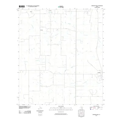
2010 Map of Christine West
USGS Topo · Published 2010About this map
Christine serves as the primary hub in this South Texas landscape, where the intersection of FM 140 and Christine Rd anchors a network of local thoroughfares. The terrain is defined by a dendritic drainage system including the winding courses of Turkey Creek, La Parita Creek, and Goose Creek. To the northwest, the Jourdanton Oil Field signifies the region's industrial ties to energy extraction, while the presence of Schorsch Lake, impounded by Schorsch Dam, indicates managed water resources in this ranching country. The small settlement of La Parita sits along La Parita Rd, surrounded by numerous county roads like Co RD 328 and Co RD 331, illustrating a rural development pattern common to Atascosa County. This survey provides a clear view of the land before significant modern expansion, preserving the locations of family-named roads and remote creek crossings.
Find a feature on this map
30 named features on this map. Tap any name to fly to it.
Don’t see what you’re looking for? This feature index may not catch every label — zoom into the map to look around manually.
Map Details
Editions of this 2010 Christine West Map
This is the sole edition of this map. No revisions or reprints were ever made.
Other maps of this area

1930 · Whitsett
USGS Topo · 1:62,500

1942 · Whitsett
USGS Topo · 1:62,500

1953 · Crystal City
USGS Topo · 1:250,000

1955 · Crystal City
USGS Topo · 1:250,000

1956 · Pleasanton
USGS Topo · 1:62,500

1956 · Jourdanton
USGS Topo · 1:62,500

1956 · Franklin Settlement
USGS Topo · 1:62,500

1961 · Crystal City
USGS Topo · 1:250,000
1965 · Caballos Creek
USGS Topo · 1:24,000

1968 · Crystal City
USGS Topo · 1:250,000