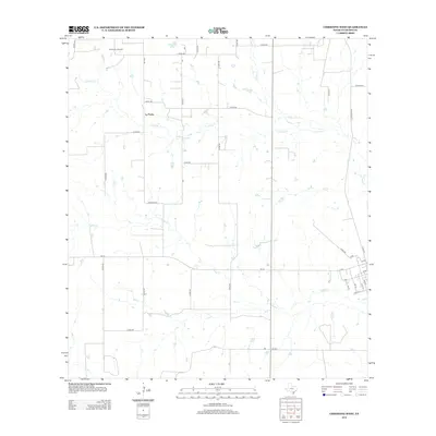
2013 Map of Christine West
USGS Topo · Published 2013About this map
Jourdanton Oil Field occupies the northwest corner of this South Texas landscape, where energy extraction meets an intricate network of rural drainage. The terrain is defined by the eastward flow of La Parita Cr and Turkey Cr, creating a landscape punctuated by small stock tanks and the larger Schorsch Lake. The settlement of La Parita serves as a central landmark within a grid of county roads, showing the persistent agricultural and ranching footprint of Atascosa County. Near the eastern edge, the transition toward the town center is marked by a sudden tightening of the grid, including Christine Rd and the alphabetically named avenues like A Ave and E Ave, reflecting the organized expansion of the local township and its surrounding rural infrastructure.
Find a feature on this map
38 named features on this map. Tap any name to fly to it.
Don’t see what you’re looking for? This feature index may not catch every label — zoom into the map to look around manually.
Map Details
Editions of this 2013 Christine West Map
This is the sole edition of this map. No revisions or reprints were ever made.
Other maps of this area

1930 · Whitsett
USGS Topo · 1:62,500

1942 · Whitsett
USGS Topo · 1:62,500

1953 · Crystal City
USGS Topo · 1:250,000

1955 · Crystal City
USGS Topo · 1:250,000

1956 · Pleasanton
USGS Topo · 1:62,500

1956 · Jourdanton
USGS Topo · 1:62,500

1956 · Franklin Settlement
USGS Topo · 1:62,500

1961 · Crystal City
USGS Topo · 1:250,000
1965 · Caballos Creek
USGS Topo · 1:24,000

1968 · Crystal City
USGS Topo · 1:250,000