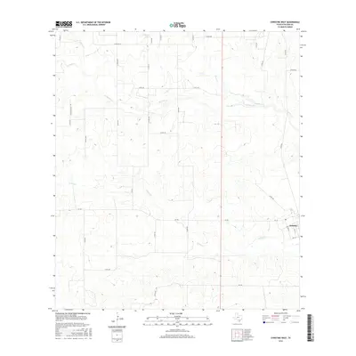
2016 Map of Christine West
USGS Topo · Published 2016About this map
Christine occupies the eastern edge of this Atascosa County landscape, situated where the grid of 1 Ave and 3rd St meets the open range. The terrain is defined by a dense network of intermittent watercourses, including the westward reaches of Turkey Cr and Goose Cr, which carve through the brush country. The map reveals a land divided into large ranching or agricultural tracts, connected by a systematic web of county roads such as La Parita Rd and the family-named Buchenschultz Trl. Near the northern border, Schorsch Lake and the headwaters of Stancel Cr provide rare permanent water features in this semi-arid environment. This 2016 survey captures the rural character of the South Texas plains, showing a landscape where modern infrastructure like FM 140 follows the same natural drainage patterns that have historically dictated settlement and transit in the region.
Find a feature on this map
35 named features on this map. Tap any name to fly to it.
Don’t see what you’re looking for? This feature index may not catch every label — zoom into the map to look around manually.
Map Details
Editions of this 2016 Christine West Map
This is the sole edition of this map. No revisions or reprints were ever made.
Other maps of this area

1930 · Whitsett
USGS Topo · 1:62,500

1942 · Whitsett
USGS Topo · 1:62,500

1953 · Crystal City
USGS Topo · 1:250,000

1955 · Crystal City
USGS Topo · 1:250,000

1956 · Pleasanton
USGS Topo · 1:62,500

1956 · Jourdanton
USGS Topo · 1:62,500

1956 · Franklin Settlement
USGS Topo · 1:62,500

1961 · Crystal City
USGS Topo · 1:250,000
1965 · Caballos Creek
USGS Topo · 1:24,000

1968 · Crystal City
USGS Topo · 1:250,000