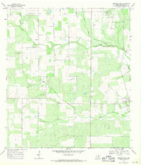
1968 Map of Christine West
USGS Topo · Published 1971About this map
The Jourdanton Oil Field dominates the northwest corner of this Atascosa County landscape, reflecting the heavy industrial presence of petroleum extraction in the late 1960s. Numerous Oil Wells, a Drill Hole, and a prominent Pipeline network crisscross the terrain, showing the infrastructure of the energy economy. In the southeast, the town of Christine serves as a small population hub, bordered by a Cem and the winding course of Turkey Creek. The area is characterized by several intermittent waterways, including La Parita Creek and Goose Creek, which cut through the ranchland and oil fields. Near the settlement of La Parita, the map identifies Gravel Pits, pointing to local resource extraction beyond oil. This survey, based on 1967 photography, documents the specific intersections of rural South Texas life and the mineral wealth that reshaped its geography.
Find a feature on this map
13 named features on this map. Tap any name to fly to it.
Don’t see what you’re looking for? This feature index may not catch every label — zoom into the map to look around manually.
Map Details
Editions of this 1968 Christine West Map
This is the sole edition of this map. No revisions or reprints were ever made.
Other maps of this area

1930 · Whitsett
USGS Topo · 1:62,500

1942 · Whitsett
USGS Topo · 1:62,500

1953 · Crystal City
USGS Topo · 1:250,000

1955 · Crystal City
USGS Topo · 1:250,000

1956 · Pleasanton
USGS Topo · 1:62,500

1956 · Jourdanton
USGS Topo · 1:62,500

1956 · Franklin Settlement
USGS Topo · 1:62,500

1961 · Crystal City
USGS Topo · 1:250,000
1965 · Caballos Creek
USGS Topo · 1:24,000

1968 · Crystal City
USGS Topo · 1:250,000