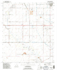
1992 Map of Chuichu
USGS Topo · Published 1995About this map
Chuichu and the surrounding desert plains of the Tohono O'odham Nation are captured here as they appeared in the early 1990s. The landscape is defined by the sophisticated hydrological management required for desert life, showing the paths of the Santa Rosa Canal and Casa Grande Canal alongside natural drainage systems like Santa Cruz Wash and Greene Wash. This survey details the intersection of traditional land and expanding infrastructure, where the Casa Grande Corporate Boundary meets local landmarks such as the Ocatillo Sch and a local Cemetery.
Find a feature on this map
24 named features on this map. Tap any name to fly to it.
Don’t see what you’re looking for? This feature index may not catch every label — zoom into the map to look around manually.
Map Details
Editions of this 1992 Chuichu Map
This is the sole edition of this map. No revisions or reprints were ever made.
Other maps of this area

1922 · Casa Grande
USGS Topo · 1:62,500

1922 · Signal Peak
USGS Topo · 1:62,500

1924 · Signal Peak
USGS Topo · 1:62,500

1924 · Casa Grande
USGS Topo · 1:62,500

1942 · Silver Reef Mountains
USGS Topo · 1:62,500

1947 · Eloy
USGS Topo · 1:62,500

1948 · Eloy
USGS Topo · 1:62,500

1956 · Tucson
USGS Topo · 1:250,000

1958 · Tucson
USGS Topo · 1:250,000

1959 · Tucson
USGS Topo · 1:250,000