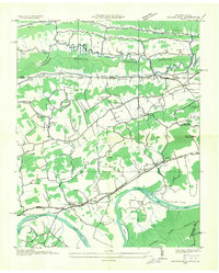
1935 Map of Church Hill
USGS Topo · Published 1935About this map
The Holston River winds through the southern reaches of this landscape, its course marked by Hord Island, Hawkins Islands, and the historic crossing at Solitude Ford. Compiled from aerial photographs in the mid-1930s by the Tennessee Valley Authority, the area reveals a dense network of valley settlements and rural infrastructure. Local life centered on numerous country schools like Grange Hall Sch and Rocky Hill Sch, alongside landmarks like Bradshaw Mill. Transportation was defined by the Clinchfield RR and Southern RR, which pierced the terrain via the Click Tunnel and Sensabaugh Tunnel. This period captures the region just as the Hydro-Electric Line and State Highway No 1 began modernizing the valley's connection to the broader Appalachian corridor.
Find a feature on this map
72 named features on this map. Tap any name to fly to it.
Don’t see what you’re looking for? This feature index may not catch every label — zoom into the map to look around manually.
Map Details
Editions of this 1935 Church Hill Map
This is the sole edition of this map. No revisions or reprints were ever made.
Other maps of this area

1892 · Greeneville
USGS Topo · 1:125,000

1894 · Estillville
USGS Topo · 1:125,000

1896 · Greeneville
USGS Topo · 1:125,000

1904 · Greeneville
USGS Topo · 1:125,000

1935 · Surgoinsville
USGS Topo · 1:48,000

1935 · Lovelace
USGS Topo · 1:24,000

1935 · Sullivan Gardens
USGS Topo · 1:24,000

1935 · Moggasin
USGS Topo · 1:48,000

1935 · Kingsport
USGS Topo · 1:24,000

1935 · Clinchport
USGS Topo · 1:24,000