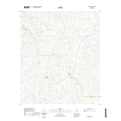
2020 Map of Church Hill
USGS Topo · Published 2020About this map
Church Hill anchors this rural landscape along the boundary of Marion and Webster County, where the terrain is defined by the winding paths of Kinchafoonee Cr and Lannahassee Cr. The map reveals a community structured around its spiritual and memorial sites, including Smyrna Cem, Shiloh Cem, and Old Union Cem. These landmarks, along with family-named routes like CE McGlaun Rd, Sarah Dew Rd, and Bob Savel Rd, provide a detailed record of local landownership and genealogy. The hydrologic network is particularly dense, with numerous tributaries such as Slaughter Cr, Christmas Br, and Dry Cr feeding into the larger creeks, while Simmons Lake and Flanigans Pond offer permanent water features amidst the wooded draws of this West Georgia region.
Find a feature on this map
47 named features on this map. Tap any name to fly to it.
Don’t see what you’re looking for? This feature index may not catch every label — zoom into the map to look around manually.
Map Details
Editions of this 2020 Church Hill Map
This is the sole edition of this map. No revisions or reprints were ever made.
Other maps of this area

1949 · Glen Alta
USGS Topo · 1:24,000

1950 · Buena Vista
USGS Topo · 1:24,000

1950 · Buena Vista
USGS Topo · 1:62,500

1955 · Buena Vista
USGS Topo · 1:24,000
1955 · Glen Alta
USGS Topo · 1:24,000
1955 · Buena Vista
USGS Topo · 1:62,500

1955 · Phenix City
USGS Topo · 1:250,000

1957 · Phenix City
USGS Topo · 1:250,000

1958 · Phenix City
USGS Topo · 1:250,000

1971 · Tazewell South
USGS Topo · 1:24,000