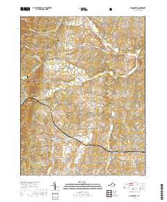
2019 Map of Churchville
USGS Topo · Published 2019About this map
Little North Mountain and Crawford Knob dominate the western horizon of this portion of Augusta County, where the eastern slopes of the George Washington National Forest meet the rolling valley floor. The landscape is defined by the winding course of the Middle River and its numerous tributaries, including Jennings Branch and Eidson Cr. This 2019 survey documents a well-settled agricultural and residential corridor centered on Churchville and West View, connected by the historic route of the Parkersburg Tpke. The map provides significant detail for local historians, marking small communities like Lone Fountain, Swoope, and Trimbles Mill. Settlement patterns follow the water gaps and creek valleys, with several family-named landmarks and cemeteries like Hunters Cem and Green Hill Cem scattered across the rural landscape between the forested ridges and the growing residential pockets near Cedar Green and Snyder.
Find a feature on this map
106 named features on this map. Tap any name to fly to it.
Don’t see what you’re looking for? This feature index may not catch every label — zoom into the map to look around manually.
Map Details
Editions of this 2019 Churchville Map
This is the sole edition of this map. No revisions or reprints were ever made.
Other maps of this area

1894 · Staunton
USGS Topo · 1:125,000

1924 · Mc Dowell
USGS Topo · 1:62,500

1943 · Craigsville
USGS Topo · 1:62,500

1944 · Parnassus
USGS Topo · 1:62,500

1944 · Mc Dowell
USGS Topo · 1:62,500

1944 · Staunton
USGS Topo · 1:62,500

1945 · Craigsville
USGS Topo · 1:62,500

1946 · Mc Dowell
USGS Topo · 1:62,500

1947 · Staunton
USGS Topo · 1:62,500

1947 · Parnassus
USGS Topo · 1:62,500