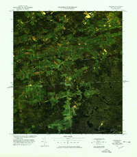
1977 Map of Churubusco Station
USGS Topo · Published 1978About this map
Customs checkpoints and international transit corridors define this unique color image map along the Canada United States border. Centered on the crossing at Churubusco Station, the landscape reveals a mosaic of forest and agricultural clearings typical of the northern Frontier. The infrastructure of international law enforcement is clearly marked by the Churubusco Station U S Customs and Franklin Center Canadian Customs facilities.
Find a feature on this map
20 named features on this map. Tap any name to fly to it.
Don’t see what you’re looking for? This feature index may not catch every label — zoom into the map to look around manually.
Map Details
Editions of this 1977 Churubusco Station Map
This is the sole edition of this map. No revisions or reprints were ever made.
Other maps of this area

1915 · Churubusco
USGS Topo · 1:62,500

1915 · Chateaugay
USGS Topo · 1:62,500

1943 · Churubusco
USGS Topo · 1:62,500

1943 · Chateaugay
USGS Topo · 1:62,500

1948 · Ogdensburg
USGS Topo · 1:250,000

1950 · Lake Champlain
USGS Topo · 1:250,000

1951 · Ogdensburg
USGS Topo · 1:250,000

1953 · Ogdensburg
USGS Topo · 1:250,000

1958 · Lake Champlain
USGS Topo · 1:250,000

1961 · Ogdensburg
USGS Topo · 1:250,000