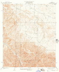
1938 Map of Cima Mesa
USGS Topo · Published 1938About this map
The San Andreas Rift Zone carves a distinct geological path across this 1930s landscape, marking the dramatic transition where the Antelope Valley meets the rising San Gabriel Mountains. This survey illustrates a sparsely settled region defined by high-desert ranching and water management, with Saunders Ranch and Stanton Ranch serving as primary landmarks. The presence of an Abandoned Ditch and numerous scattered labels for Well and Spring underscore the critical importance of water rights and irrigation in this arid environment.
Find a feature on this map
24 named features on this map. Tap any name to fly to it.
Don’t see what you’re looking for? This feature index may not catch every label — zoom into the map to look around manually.
Map Details
Editions of this 1938 Cima Mesa Map
This is the sole edition of this map. No revisions or reprints were ever made.
Other maps of this area

1900 · Tujunga
USGS Topo · 1:62,500

1901 · Southern California Sheet No. 1
USGS Topo · 1:250,000

1903 · Rock Creek
USGS Topo · 1:62,500

1904 · Southern California Sheet No. 1
USGS Topo · 1:250,000

1915 · Elizabeth Lake
USGS Topo · 1:125,000

1917 · Elizabeth Lake
USGS Topo · 1:125,000

1930 · Little Rock
USGS Topo · 1:24,000

1930 · Llano
USGS Topo · 1:24,000

1930 · Pearland
USGS Topo · 1:24,000

1934 · Pearland
USGS Topo · 1:24,000