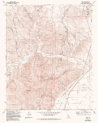
1972 Map of Cinco
USGS Topo · Published 1994About this map
Fremont Valley floor meets the sharp rising ridges of the eastern Sierra Nevada foothills in this survey from the early 1970s. The small settlement of Cinco sits at the base of the mountains, positioned near the critical path of the Los Angeles Aqueduct and the Los Angeles Second Aqueduct which parallel the valley edge. Resource extraction and infrastructure define the area's development, evidenced by the Mohawk Buddy Mine and White Rock Mine tucked into the canyons. High-elevation landmarks like Bald Chuckwalla Mtn and Sugarloaf Peak overlook deep-cut drainages such as Jawbone Canyon and Butterbredt Canyon. The map records essential water sources in this arid landscape, including Alphonse Spring and Cutterbank Spring, alongside the eastern edge of the Red Rock Canyon Recreation Area.
Find a feature on this map
32 named features on this map. Tap any name to fly to it.
Don’t see what you’re looking for? This feature index may not catch every label — zoom into the map to look around manually.
Map Details
Editions of this 1972 Cinco Map
3 editions found
Other maps of this area

1915 · Searles Lake
USGS Topo · 1:250,000

1915 · Mojave
USGS Topo · 1:125,000

1943 · Cross Mountain
USGS Topo · 1:62,500

1943 · Saltdale
USGS Topo · 1:62,500

1943 · Castle Butte
USGS Topo · 1:62,500

1943 · Mojave
USGS Topo · 1:62,500

1947 · Castle Butte
USGS Topo · 1:50,000

1947 · Trona
USGS Topo · 1:250,000

1948 · Trona
USGS Topo · 1:250,000

1948 · Bakersfield
USGS Topo · 1:250,000