
1995 Map of Ciniza
USGS Topo · Published 1998About this map
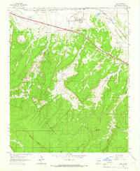
The Ciniza Refinery and its associated industrial infrastructure anchor the northern edge of this New Mexico landscape, situated just south of the South Fork Puerco River. This industrial hub, complete with the Ciniza Landing Strip, Sludge Pits, and Sewage Disposal facilities, stands in stark contrast to the protected wilderness of the Cibola National Forest to the south. Transportation history is etched into the terrain via an Old Railroad Grade that winds through Sixmile Canyon.
Find a feature on this map
32 named features on this map. Tap any name to fly to it.
Don’t see what you’re looking for? This feature index may not catch every label — zoom into the map to look around manually.
Map Details
Editions of this 1995 Ciniza Map
This is the sole edition of this map. No revisions or reprints were ever made.
Other maps of this area

1886 · Wingate
USGS Topo · 1:250,000

1892 · Wingate
USGS Topo · 1:250,000

1954 · Gallup
USGS Topo · 1:250,000

1958 · Gallup
USGS Topo · 1:250,000

1959 · Gallup
USGS Topo · 1:250,000

1961 · Cottonwood Canyon
USGS Topo · 1:24,000

1962 · Gallup
USGS Topo · 1:250,000
1962 · Ciniza
USGS Topo · 1:24,000
1962 · Continental Divide
USGS Topo · 1:24,000

1962 · Cottonwood Canyon
USGS Topo · 1:24,000