
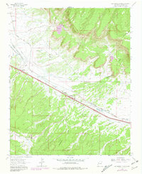
1962 Map of Continental Divide
USGS Topo · Published 1966About this map
The high desert landscape of McKinley County is defined by the rugged crest of the Continental Divide, where water begins its journey toward either the Atlantic or Pacific oceans. This mid-1960s survey documents a critical transportation corridor through the Cibola National Forest, dominated by the heavy infrastructure of the Atchison Topeka and Santa Fe railroad and the modern path of Route 66. The settlement at Coolidge serves as a focal point for local life, featuring the Coolidge Navajo Ch and a central Post Office.
Find a feature on this map
21 named features on this map. Tap any name to fly to it.
Don’t see what you’re looking for? This feature index may not catch every label — zoom into the map to look around manually.
Map Details
Editions of this 1962 Continental Divide Map
2 editions found
Other maps of this area

1886 · Wingate
USGS Topo · 1:250,000

1892 · Wingate
USGS Topo · 1:250,000

1954 · Gallup
USGS Topo · 1:250,000

1958 · Gallup
USGS Topo · 1:250,000

1959 · Gallup
USGS Topo · 1:250,000

1961 · Cottonwood Canyon
USGS Topo · 1:24,000

1962 · Gallup
USGS Topo · 1:250,000

1962 · Ciniza
USGS Topo · 1:24,000

1962 · Cottonwood Canyon
USGS Topo · 1:24,000

1962 · Page
USGS Topo · 1:24,000