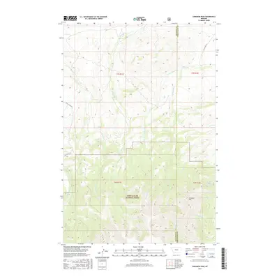
2017 Map of Cinnamon Peak
USGS Topo · Published 2017About this map
Lewis & Clark National Forest encompasses the southern portion of this landscape, where the terrain rises toward the summit of Cinnamon Peak. The map documents a complex drainage system where Little Elk Creek and Lost Horse Creek cut through the western sections, while the headwaters of Miller Creek and its branches, the West Fork Miller Creek and East Fork Miller Creek, dominate the central and eastern reaches. A stark boundary line between Meagher and Wheatland Counties runs vertically through the survey, marking a jurisdictional divide in this high-country environment. Human footprint is limited to the periphery, with Crazy M Ranch Rd and Miller Creek Rd providing access to the more accessible northern foothills, while interior features like Bear Spring and Station Creek serve as vital water markers in the higher elevations.
Find a feature on this map
20 named features on this map. Tap any name to fly to it.
Don’t see what you’re looking for? This feature index may not catch every label — zoom into the map to look around manually.
Map Details
Editions of this 2017 Cinnamon Peak Map
This is the sole edition of this map. No revisions or reprints were ever made.
Other maps of this area

1886 · Little Belt Mts.
USGS Topo · 1:250,000

1894 · Little Belt Mts.
USGS Topo · 1:250,000

1897 · Little Belt Mts.
USGS Topo · 1:250,000

1898 · Little Belt Mts.
USGS Topo · 1:250,000

1902 · Little Belt Mts.
USGS Topo · 1:250,000

1948 · White Sulphur Springs
USGS Topo · 1:250,000

1958 · White Sulphur Springs
USGS Topo · 1:250,000

1961 · White Sulphur Springs
USGS Topo · 1:250,000

1965 · White Sulphur Springs
USGS Topo · 1:250,000
1972 · Virginia Peak
USGS Topo · 1:24,000