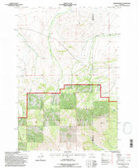
1995 Map of Cinnamon Peak
USGS Topo · Published 1997About this map
The high ridges of Cinnamon Peak dominate the southern portion of this landscape, marking a prominent point within the Lewis and Clark National Forest. This 1990s survey by the Forest Service reveals the complex boundary between the Musselshell Ranger District and private lands to the north. While most of the terrain is characterized by steep drainages like Little Elk Creek and Lost Horse Creek, isolated outposts of human activity appear in the form of the Pump Ranch and the Bear Spring Station. A solitary Drill Hole in the northern hills points to historical geological exploration or water management. The map also delineates the jurisdictional line between Meagher and Wheatland counties, where the headwaters of Miller Creek and Cinnamon Creek flow through diverse forest and grazing lands.
Find a feature on this map
18 named features on this map. Tap any name to fly to it.
Don’t see what you’re looking for? This feature index may not catch every label — zoom into the map to look around manually.
Map Details
Editions of this 1995 Cinnamon Peak Map
This is the sole edition of this map. No revisions or reprints were ever made.
Other maps of this area

1886 · Little Belt Mts.
USGS Topo · 1:250,000

1894 · Little Belt Mts.
USGS Topo · 1:250,000

1897 · Little Belt Mts.
USGS Topo · 1:250,000

1898 · Little Belt Mts.
USGS Topo · 1:250,000

1902 · Little Belt Mts.
USGS Topo · 1:250,000

1948 · White Sulphur Springs
USGS Topo · 1:250,000

1958 · White Sulphur Springs
USGS Topo · 1:250,000

1961 · White Sulphur Springs
USGS Topo · 1:250,000

1965 · White Sulphur Springs
USGS Topo · 1:250,000
1972 · Virginia Peak
USGS Topo · 1:24,000